-> Till the Ocean Turns Blue
Interactive Map, Soundwalk
Data visualization and sonification of North Atlantic Right Whale(NARW), 2020 Tools: Openprocessing, Excel data sheet, Field recorder & microphones, Reaper, Adobe Illustrator, HTML/css/Javascript
![]()
With an estimated population at less than 500 individuals by 2020, North Atlantic Right Whale is one of the most threatened in the world due to the intensive hunting that had been practised for centuries.
For the North Atlantic Right Whale(NARW),
- Tour 1: Journey of NARW, Interactive Map
![]()
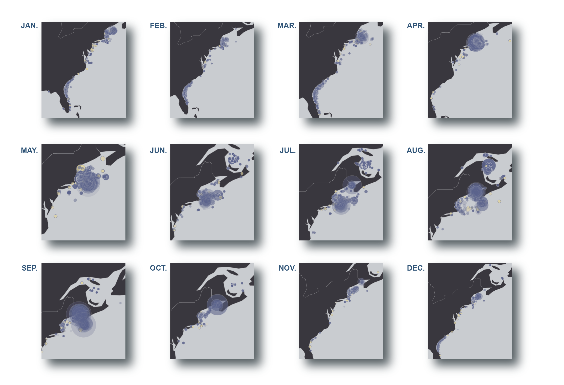
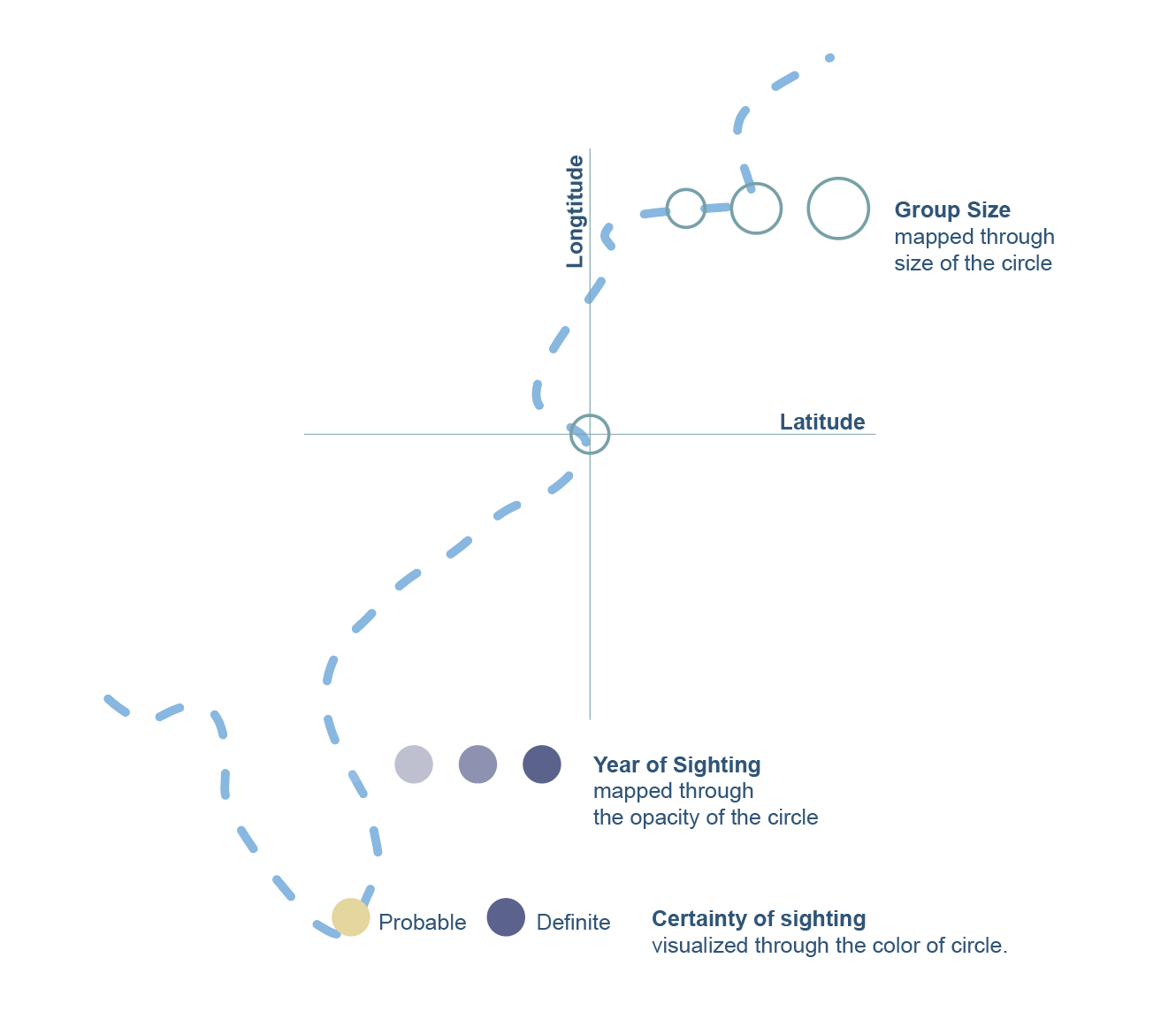
Sighting data of North Atlantic Right Whale, either dedicated or opportunistic, is a great source for understanding the creature. Project Journey of NARW takes the sighting data of date, latitude and longtitude, group size, and certainty of sighting, trying to mapped out the migration and social preferences of NARW group.
![]()
This interactive map covers 13201 rows of dataset about the sighting details of North Atlantic Right Whale(NARW) from 2002 to 2018. By taking month as the key factor of analyzing, the map is able to visualize the rough migration route of NARW.Each circle on this map represents a seperate witness with each circle representing a seperate witness.
![]()
- Tour 2: Till the Ocean Turns Blue, Soundwalk
Collaborated with: Maike Prewett
![]()
Interactive Map, Soundwalk
Data visualization and sonification of North Atlantic Right Whale(NARW), 2020 Tools: Openprocessing, Excel data sheet, Field recorder & microphones, Reaper, Adobe Illustrator, HTML/css/Javascript

With an estimated population at less than 500 individuals by 2020, North Atlantic Right Whale is one of the most threatened in the world due to the intensive hunting that had been practised for centuries.
For the North Atlantic Right Whale(NARW),
- Tour 1: Journey of NARW, Interactive Map
Sighting data of North Atlantic Right Whale, either dedicated or opportunistic, is a great source for understanding the creature. Project Journey of NARW takes the sighting data of date, latitude and longtitude, group size, and certainty of sighting, trying to mapped out the migration and social preferences of NARW group.

This interactive map covers 13201 rows of dataset about the sighting details of North Atlantic Right Whale(NARW) from 2002 to 2018. By taking month as the key factor of analyzing, the map is able to visualize the rough migration route of NARW.Each circle on this map represents a seperate witness with each circle representing a seperate witness.
- Tour 2: Till the Ocean Turns Blue, Soundwalk
Collaborated with: Maike Prewett

Mapped on to the Lujiazui pedestrian bridge in Shanghai, China, the soundwalk invites the audience go on an immersive tour with the NARW by taking the surrounding urban landscape as a measuring tool. It is a demo created for the Wildlife Conservation Society, and is meat to be eventually adapted to the city of New York and its landmarks. It runs for 12:38 minutes.
